Thursday, December 31, 2020

Grand Canyon National Park 3 days 2 nights Rim-to-Rim-to-Rim

I added hiking rim to rim in Grand Canyon National Park to my bucket list a few years ago. I had joined a postcard exchange program in collage and one of the most coveted postcards was one sent from the bottom of the Grand Canyon. So, unlike the reason most people want to do rim to rim, the main reason for me was sending a postcard mailed by mule from Phantom Ranch at the bottom of the Grand Canyon. We tried to plan the rim to rim trip two times, but failed for different reasons. Typically, people hiked from North Rim to South Rim (or vice versa) and take a four and a half hour trans-canyon shuttle back. After the COVID-19 pandemic, we started to consider the possibility to do a rim to rim to rim ( R2R2R) since we didn't feel safe taking the shuttle bus. It would also mean we could hike all three primary Grand Canyon National park corridors: Bright Angel, South Kaibab, and North Kaibab in one trip. After much deliberation and planning, we finally secured our two night camp spot at the end of November ten days before our departure day. 

Below is the itinerary we used to apply for the permit and would eventually complete: 

Day 1 (11/28/2020): Bright Angel Trailhead-> South Kaibab Trailhead(via Rim Trail)-> Phantom Ranch-> Cottonwood Campground (via North Kaibab Trail)

Day 2 (11/29/2020): Cottonwood Campground-> North Kaibab Trailhead-> Cottonwood Campground

Day 3 (11/30/2020): Cottonwood Campground-> Phantom Ranch-> Bright Angel Trailhead

The ranger approved our plans but added the following comment: "aggressive plan to reach the cottonwood campground on the first day". 

Day 1: 

We camped in KOA Grand Canyon/ Williams the night before our hike and barely got any sleep because the temperature dipped to 22F/-6C at night. We always wondered when the temperature would be too cold for camping; I guesses we finally found the answer in a unpleasant way. We woke up before our 5 o'clock alarm, and for the very first time I couldn't wait to get out of my sleeping bag.  On our 55 minutes drive to the Grand Canyon, we ate croissants that we bought from Las Vegas the day before. Under sub 32F temperatures, the croissant tasted like its main ingredient: butter. 

We parked our car at Parking Lot D, right next to the backcountry information center, and started our three day adventure at 7:15 AM. We didn't take the free shuttle from the lot to South Kaibab Trailhead, but hiked the Rim Trail instead. On the Rim Trail, we saw the canyon for the very first time, and the enormity was mind-boggling. As promised, the canyon did look grand. As I surveyed the great abyss, I felt dwarfed and intimidated. I couldn't stop all the negative thoughts like: was our plan was too ambitious or could I  drag myself back to the south rim three days later. At one point, I even questioned why we were skipping our thanksgiving meal and instead planned to eat dehydrated food on the bottom of the canyon.  

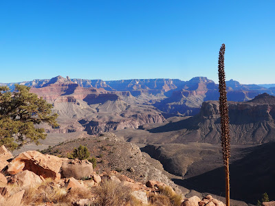
My anxiety grew after the decent on South Kaibab Trail. The trail was marked with signs to remind hikers about the danger of hiking below the rim. One sign read "Down is optional, Up is mandatory.". The other one had a picture of a sun-burned hiker projectile vomiting. William, haunted by the ranger's comment, tried to keep our pace above 3 miles per hour. In order to keep up with him, I put my worries and thoughts aside and focused on one thing, descend. The South Kaibab Trail provides some of the most expansive views on the entire hike. You can see miles of ridges, temples and buttes bathed in the autumn sun. Every few steps down, the rock changed shade or texture, even the dirt on the trail changed color: sand beige, copper brown, rust red, and sage green. Right after Skeleton Point, we had our first glance of the emerald green Colorado River. Although we were still miles away from it, it did give us a jolt of joy. We encountered a mule train coming up from Phantom Ranch carrying supplies. I was amazed by the handler's ability to control 6 mules at once. We were passed by a group of three hikers played tag as they racing down the trail. With the playground game, they made their decent really fun. Considering the ability difference between me and William, I probably would be "it" forever. The Colorado River served as a carrot and we managed to pick up the pace. Before we knew it, we reached the tunnel leading to the Kaibab Trail Suspension bridge (Black Bridge). Later, after seeing old historical pictures of what river crossing used to be, with precarious cableway, I was very thankful that we had a reliable bridge to cross the river.  

Soon after the river crossing, we reached Phantom Ranch and had a short hour long lunch break there. We bought lemonade with ice and postcards pre-stamped with "Mailed  by mule at the bottom of the Grand Canyon". Enjoying the cold lemonade in this off-grid place felt magical. We also refilled our water bladders since we found out at Bright Angel Campground that there was no potable water on the entire North Kaibab trail due to a pipeline break. 

After leaving the ranch, we followed the trail which narrowed as it twisted through the gorge. Bright Angel Creek incised into rock layers of pink Zoroaster granite and black Vishnu schist. I sometimes feel time slows to a creep when I hike, especially during long hikes that test my endurance. As we mender through the towering rock dating back 1.8 billion years, I just realized how rapidly I traveled back in geologic time during the decent from the South Rim to the Colorado river. As we gained elevation, the view widened and the surrounding meadows were filled with desert scrub and scattered with cactuses like prickly pear, hedgehog, and beavertail. The Utah agave had towering flower stalks (~15 feet) that amazed me.

We arrived at Cottonwood Campground around 4 PM after 8.5 hours of hiking. We were exhausted from our exertion but elated because we made it to the campsite before sunset. The campground lies along the North Kaibab trail and consists of 11 small sites (1- 6 people) and 1 group sites. Three sites were occupied when we arrived. We chose campground #6 because it offered the best privacy and shade. Drinking water  was only available from mid-May to mid-October so we knew to bring a water filter and find water. We were thankful that there was a trail from the back of our campsite that lead to the Bright Angel Creek which made it easier to access a water source. 


Day 2: 

After a good night of sleep, we left most of our gear in the campground and proceeded on a day hike to North Rim. We started our hike at 8 AM. 

We saw Roaring Springs Waterfall on our right. Water gushed out of a hole in the towering cliff walls. The small pump house hanging on the canyon walls is visible if you zoom in. The Roaring Springs provides potable water for the South Rim and Cross Canyon Corridor. It was a surprise to me that the Colorado River provides water to nearly 40 million people but not to the Grand Canyon National Park it passes through. The trail continues by cutting through redwall limestone formations and the whole canyon glowed rust red in the morning sun. The trail became narrower here with sheer red rock on one side and cliff on the other. All of the sudden, we saw Redwall Bridge below us. After 0.6 miles and numerous switch backs, we passed through the 20 foot long Supai Tunnel. As we continued our way up, the forest became denser with lush green ponderosa pines and red maple trees. We reached North Kaibab Trailhead at around 11AM. 

Our original plan was to hike another 0.9 mile to the Bright Angel Point and to see the canyon from a different perspective. However, after walking a quarter mile on an icy trail, we saw a wooden sign: trail closed due to winter conservation. So we decided to turn around and head back to the Cottonwood Campground. On the way back to trailhead, we met a couple with their dog asking direction to see the canyon. They told us that they put Grand Canyon into google search and the GPS kept leading them to North Rim Campground. Originally, we suggested them to go to Coconino Overlook but soon remembered dogs are not allowed on North Kaibab Trail. Without any better suggestion, we saw them leave frustrated. I really hope they eventually saw the canyon. After finishing our hike at 2:17 PM, we spent the rest of the day writing postcards, wandering around the campground, and rinsing salt from our bodies in the frigid Bright Angel Creek. 

Roaring Springs Waterfall 

Redwall Bridge

Day 3: 

We arose as planned at 5 AM for our 18 mile hike out. In my opinion, it was the most challenging day in this backpacking trip because it would be a long and continuous uphill hike with heavy backpacks, and we would have to do this with the accumulated fatigue from previous days. How we made the day more strenuous by driving 7 hours home after the hike was another story.  We packed our tent, ate oatmeal for breakfast and headed out at 6:30 before dusk. 

The first part of hike was a mild downhill. We spotted distant flashes of light from the South Rim. It seemed really far and it was hard to believe we'll be there by this afternoon. Although we passed this section two days ago, the difference in light settings and perspectives still amazed us as we wound our way down through gorges and passed the bridges across Bright Angle Creek. By 9 AM, we reached Phantom Ranch, and the mule train had arrived. I put our postcards into an ammo canister which they used as a mailbox and felt a bit jealous that the cards would have a mule ride up to the south rim. After leaving the ranch, we walked through Bright Angle Campground and crossed the silver suspension bridge. We stayed in the middle and looked at the river flowing beneath us. 

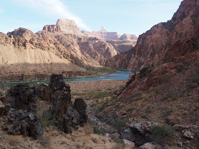
After crossing the river, we walked on the sand dunes along the south bank of the Colorado River for the next 1.5 miles. We enjoyed the view of boulders on turquoise water and imagined the river runners shooting around the bend in the summer. Upon arriving at River Resthouse, we took the last glance and said goodbye to the Colorado River. As we hiked up the Bright Angel Trail along the pipe creek, William's keen eyes spotted a female desert bighorn sheep on the top of sandstone. The fur of bighorn sheep serves as a perfect camouflage among the buttes and bushes. Then we entered a section with a notorious name: Devil's Corkscrew. It is named because of grueling summer temperature and serious of switchbacks resembling the corkscrew. In the summer, the temperature here can sometimes reach 130F/54C in the afternoon. Nonetheless, with temperature around 55F/12C, we adored the peaceful autumn scene, the yellow cottonwood leaves sparkled under the sun against a backdrop of gray black towering schist. Occasionally, we saw the mule deers grazing close to the trail. The peaceful scenery was suddenly interrupted as a runner emerged from the cottonwood trees and ran swiftly towards us. When we realized the runner was Jim Walmsley, America's best male ultra-runner, he already passed us with unbreaking pace. He broke the record for Western state 100-miles in back-to-back years (2018 & 2019) and holds the fastest known time (5:55:20 in 2016) for R2R2R. Seeing Jim Walmsley invigorated us like receiving a adrenaline boost as we labored our way up. We had a brief stop for water in Cottonwood Campground, and reached the 3 mile Resthouse around 1PM. 

For the last three miles, the trail was along a vertical wall with precipitous switchbacks. My glutes, hamstring and calf muscles started screaming for a break. It felt like hitting the wall at mile 20 in a marathon. I periodically looked back for a sense of accomplishment, and told my muscles " you guys have come this far, don't give up!". After the 1.5 mile Resthouse, the number of people on the trail increased dramatically, which reassure me that the trailhead was really close. After passing the last two tunnels akin to the last 800m and 400m markers in the marathon, we finally saw the finish line, the trailhead. We stood happily next to the Bright Angle Trailhead and looked back out the great distance that we had just hiked. 

The R2R2R is truly an arduous journey and an epic adventure.


Thursday, August 13, 2020

8/9/2020 Highline Trail and The Loop Trial in Glacier National Park

After stuck at our tiny one bed room apartment for five months, William and I were going crazy and really felt the need to have some getaway. I planed a four-day trip to Glacier National park and was lucky enough to reserve camp spots in fish creek campground (the only open campground in glacier NP this year) for thee nights. 

The first and last days of our trip were spending on driving, so we only had two full days to explore the park.  Due to COVID-19, much of the east side of the park is closed and there is no shuttle bus this year.    As a result, the two day hikes we picked are either out and back or loop trail. The first one we did is the Highline Trail and The Loop trail with distance 25.4 miles (blue line below). The second one is siyeh pass loop with St Mary and Virginia falls with distance 17 miles ( red line below).

Everyone we had talked about our trip mentioned bears in Glacier NP, some even had personal experiences. I read a lot about bears which only make me really anxious. I even came across a story about an accident that a jogger collided with bear and got minor injury in Glacier NP a month ago. I was so nervous and even bought a bear bell which William called diner bell. We practiced a lot of precautions like only trail run on the straight portion, making a lot of noise  on the rounding blind corners and having a bear spray handy. We had two bear encounters, fortunately, we were safe. 

8/8 our first day hike. We started at 7 AM. The trail head is across the road from Logan pass visitor center. The parking lot there was about one third full. After hiking around quarter mile from the trail head, we reached a section where the trail is carved into the cliff and we can see the Going-to-the-Sun road below. It gave us a jolt of adrenaline. We jogged the gentle uphill along the Garden Wall and enjoy the lush U-shaped valley formed by glaciation below. I learned glaciation from geography class when I was around 13, and it's really exciting to see it in person. I enjoyed the view so much and didn't even feel the major climb to reach Haystack Pass. 

At about 9 AM, we reached the junction leading to Grinnell Glacier Overlook trail. Will and I discussed if we'll see the glacier first or on the way back. We chose the second option which is not the smart decision since the trail was so packed in the early afternoon and it made social distancing impossible. 

We reached the chalet, had snack break there and took The Loop trail steeply down the mountain. The first half mile or so has a lot of tall trees and the bloom of wild flowers. Then, the canopy opened up, allowing some nice view of mountains and meadows filled with flowers. The army of bare trees burned by 2003 Trapper Creek Fire lingered on the flower field. It's hard to imagine how thick the forest used to be. 

There were a lot of huckleberry, thimbleberry and salmonberry bushes about a mile down from the Chalet. As it's said huckleberry maps hungry bears, I was really nervous and on the lookout for bears at all times. A couple also warned us about bear because they heard deer snort. Soon after they warned us, we had our first bear encounter. I was running down a straight pass and suddenly saw a bear standing on its hind legs about 100 meter away. We locked eyes and froze for a second and the bear reacted first by lowering itself. Then it went away from the trail, got back and passed the path to the other side. At this point, William and I didn't feel safe pushing forward so we turned back about a mile from The Loop trailhead.  


We informed the first hiker about the bear after we turned back. We were not sure it's a black or grizzly bear, so we showed her the pictures we took. She said it was a black bear and there is nothing to worry about since they are friendly. However, we later figured out it's a grizzly from William's coworker, a Montana native, and he thought it's quite silly to think black bears are friendly. 

We took a detour to see the Grinnell Glacier on the way back. This is the most congregated part of the whole hike.  The Grinnell Glacier overlook trail is very narrow and steep (gaining about 900 feet in 0.9 mile) but it's definitely worth the efforts as the view on the top is spectacular. The overlook gives a bird eye view of Salamander glacier, upper Grinnell Glacier Lake,  Mt. Gould and Grinnell Glacier below the north face of Mt. Gould. I hope we can have a closer look of Grinnell Glacier next time by taking Grinnell Glacier trail. 

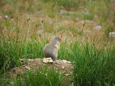
We saw a lot more mammals on the way back to Logan Pass Visitor Center. I guess when we started our hike at 7AM, it's not only too early to be active for me but also for other animals. Columbian ground squirrels were racing down the trail with us. Hoary marmots were posing on rocks. We saw 5 big horn sheeps, a white-tailed deer and a mountain goat.


It took us 8 hrs to finish the hike. According to Strava, the total mileage is 24.11 miles( 38.8 km) and the total elevation gain is 5823 feet (1775 m).  

Thursday, November 26, 2015

Our CSA vegetable share (week 6-9)

We joined the community support agriculture (CSA) program this year. We will get a box of vegetables directly from the farm for 26 weeks. Recently, I am looking forward to receiving the newsletter from the farm on Tuesday and picking up the veggies on Wednesday. I want to document what we get and how we cook these veggies. For the first 5 weeks, I was too busy to document what we got:(. 
I grow up in a small town know for growing rice in Taiwan. My mom always gets the veggies directly from the local farmers. We ate what's in season year round. Eating with the seasons is the lessons I learned from really young age. After moved to the states, since you almost can get any kind of veggies year round in supermarket, I lose my track of season on the dining table. In addition, I want to get exposed to more vegetables and new ways of cooking. Another reason is I am tired of deciding what to get and cook every week. So why not  just let the farmers make decision for me:).

Our CSA box
  • Week 6

This week we get carrots( 1 bunch), beets( 1 bunch), radicchio( 1 head), zucchini( 4 pieces) scallions( 1 bunch), red Batavian lettuce( 1 head), and kohlrabi (x3).
I found a perfect recipe( root vegetable slaw with labneh) on Jerusalem to use all of the root vegetables we got from this week's share. Although we missed celery root, the slaw still tastes really good. The vinaigrette nicely covered the beets flavor I don't like. We ate it with grill salted mackerel fish as recommend by the book( It is great to serve alongside with grilled oily fish).
Will's sisters came over for a house warming party on 4th of July. We served them meatballs with spaghetti and salad with greens we got from food share. His sisters actually are not fans of salad but they gave more compliment on salad than the meatball spaghetti. We made a few times of zucchini pasta from serious eats which is quick easy and delicious recipe.
  • Week 7

This week we got carrots( a bunch), cucumbers(x2), green cabbage( 1 head), basil( 1 bunch), zucchini(x4), red Batavian lettuce( a head), Romain lettuce( 1 head) and radicchio (1 head). I was wishing for cucumbers all last week and I finally got them. We thin sliced the cucumber and mix with lettuce, cranberry and nuts and dressed with our favorite vinaigrette. It's so yummy. We used the basil to make chicken mushroom pesto pasta. This is the first time Will and I tried the radicchio and both of us don't like the harsh bitter taste. Even the balsamic vinegar and maple syrup can not cover this intense flavor. william made fun of me and said as a person who likes bitter melon suppose can tolerate this veggie. 
  • Week 8


This week we got  swiss chard, parsley, scallions, kohlrabi, cucumbers, beets, basil, zucchinis and a head of lettuce. It a huge box.
I feel the hot summer makes the crops grow better and faster. Before, Will and I can manage to finish our veggie shares on time. Recently, no matter how hard we tried, we still have some leftover when the new food is coming. I am seriously consider to convert to a vegetarian at this point. This week we get a lot of herbs, basil, green onion and parsley. The basil looks much nicer compare my indoor one.
We used the cabbage from last week and beets to make borscht. The recipe I used which tastes really similar to the one my advisor cooks( she is from Russia). I roasted the beets at 400F for 45 mins instead of boiling them in order to get the sweetness. My advisor said her son likes to drink it cold in summer. So we tried it cold this time and it's weird because of the butter. I think I'll replace butter with olive oil next time.
We made another dish from Jerusalem, turkey and zucchini burgers. Making one dish from it every week is becoming our tradition after moved in together. So far everything we've made from it has turned out delicious. I pick this recipe this week in order to finish our zucchini. The recipe asks for one large zucchini(200g), but the zucchinis we got is about double the size. I  guess they are extra large :P. I tried one burger when it's just out from the oven and it's the most delicious one I ever had. The bursting herb flavor makes the burger light and delicious.
Turkey and zucchini burgers from Jerusalem cookbook

  • Week 9
This week we get walla walla onions (such a cute name), parsley, zucchini, cucumbers, first tomato of this season and lettuce. The food share  is lighter amount this time. According our farmer, every july they hit "lull" on their harvest. The true summer crops are not quite in yet but the earlier summer crops are ending. Actually I feel relaxed about this news. Finally, we can finish the veggies on time and don't need to convert to vegetarian. William mentioned another point to join the CSA. He said a lot of food doesn't look good ends up in dumpster since the USDA standard for food is focus on appearance of food. The interesting-shaped cucumber( second to the right) we get this week may not be sold in supermarket although it is as delicious and nutritious as the good looking one.
We made the zucchini turkey burger again since it's too delicious. We made a lot of them, put into small container and froze it. We made gazpacho. It's such a treat in a hot summer day. William use it as tortilla chips dip and it's really refreshing. We made the green sauce from serious eats and froze it. it's really useful to prepare a quick meal after work.

Friday, July 17, 2015

2015 Nike women's toronto 15k

June is a really crazy month for me. A lot of things happened, but mostly good things:) I finally passed my prelim, officially one step away from getting my PhD. Will and I had a road-trip to Canada. On June 14, We ran Nike women's Toronto 15K, which is our first road-running. Right after getting back from Canada, Will and I moved into our new apartment.

I trained with William to run the Toronto Nike women's 15km. It's such a precious experience to have a goal together and work it out. William is a great couch who always cheer me up when I was about to give up. During the training, we ran 6 mile around central park, which is one of my dream since I never knew I can run that far.  We also explored some of the local trails. I stopped my training at the end of May because of the one-week before notification for my prelim. At that time, the longest distance I can run was 8 miles. So before the race, my plan is at least run for 8 miles(12.8km) and walk for the rest.

We arrived Toronto a day before the race and picked up the package. William thought the ferry docks is the same as packet pick-up place. So we drove to the dock and wasted a little time to find the expotique before we realized we were in the wrong place. It took about ten mins walk from ferry dock to pick-up place. Since we had paid the parking for 1.5hrs, we decided to walk. The packet pickup was in a huge tent and there was no wait when we arrived. It looks like there were a lot of cool things inside the expotique but we need to go back to our car. We only had a chance to take a picture with the race map. 

Things inside my race packet
On the race day: Originally, the weather forecast said it'll be cloudy for the whole morning and rain after 1pm. However, it started raining around 9 am. Will and I wrapped our body with heat sheet but still felt really cold. We stayed in the  shield and had a small fight about when we should going to our corral. At the end William decided to stay under the tree until last minute, and I went to wait in my corral after the first wave started. I covered myself with heat sheet and only had my eyes shown. It stopped raining when wave 5 started and stayed cloudy for the rest of the race.
At the first 3km, I was basically trying to pass around people and to avoid the puddles. Then, I  ran on the Toronto city airport runway and passed the most scenic spot of this race. From there, you can see the spectacular Toronto skyline.  A lot of runners stopped and took pictures but I decided to continue. At around 6km, I saw wave 6 pacers whose finish time 1:41 is my goal, so I followed the race group for another 3km. After that, I felt I had chance to finish even faster so I left. Instead of concentrating on synchronizing my pace and following the group, I had more time to enjoy the cheerful spectators and all the interesting signs (Will and I both saw a guy hold a sign said "The sexist parade in the world", and he flashed him :p) The last 3km on the wooden boardwalk with lake view is really enjoyable. I sprint at the last 200m. I got my recovery snacks bag (no banana inside QQ) and waited for William. It started raining again at this point. After shaking and having goosebumps all over my arms for 20 minutes, I decided to get my finish necklace designed by Tiffany & co. After making an international phone call, I finally met Will in front of gear storage. He actually finished the race 10 minutes before me.


It's a really inspiring to see all the women with different fitness level, ages, but with the same goal, finishing the race. I am so happy to be one of the 10000 women participated this race. I'll keep running and plan to run a half marathon sometimes this year. Thanks William for being a good running partner. We definitely will run more race together.

Friday, October 17, 2014

2014 Adventure in iceland

We just got back from iceland! What an amazing place! The only wish is that we stayed longer. 

Let's start from the most memorable part of our trip~The two-day hike from Alftavatn to Landmannalaugar.  It's  part of the iceland's most popular hiking route, Laugavegurinn. Normally, people spend four days walking from Thorsmork to Landmannalaugar. However, since we only have five days in iceland. We decided to do a two day hike instead. We also decided to end our hike in Landmannalaugar so we can reward ourself with dipping into the hot spring. 
The first day began with the bus to Alftavatn. We parked our car in Hella and took the bus to Alftavatn. There is only one bus every day to alftavatn in summer time. The price is 6500 isk per person. When we got it in the information center in Reykjavik, we thought it's over-charged for an three-hour bus ride. But I need to say it's totally worthy. The roads on the highland have gravel surface. Our bus was even fording rivers a few times. The view is spectacular, really unique scenery. There were only three more person on the bus but we were the only hikers. 
We arrived Alftavatn at around 1:00 pm and started our hike. For the first day, the hiking distance (Alftavatn to Hrafntinnusker) was 12 km( 7.45 miles), Estimated walking time is 4 to 5 hours.  
Started our hike in Alftavatn. Both of us didn't seem ready for the hike =.=
The hike before reaching river Grashagakvisi was mostly flat. The vegetation was abundant with vividly yellow and green color. Before crossing the river, we overheard the news that an eruption started near Bárðarbunga last night from other hikers. Luckily, it's an lava eruption. No wading is required when cross  Grashagakvisi. 

After crossing the river, we experienced a series steep ascent. We passed an unusual hues of rhyolite mountains, ashen gray, rusty red, muddy yellow, and metallic brown. The field was just like a color plate of nature. White steam from from the ground adds some bizarre feel of the scene. The smell of rotten egg from the sulfur was not that appealing but it's almost the only thing reminds me that I was still on the earth. 
Soon the landscape changed. A lots of ravines were filled with snow and ice. We saw bigger and bigger patches of snow when we hiked. We even stopped by and explored one of the ice caves just next to the trail. William went through it although it's considered unsafe. The ice carve is developed by the thermal activity underneath the glacier so it's unstable. Soon after that, we had to walk on the snowy field. It's really different than the one I had in New York. It's packed but not slippery. So the crampons are not necessary. Before reaching Hrafntinnusker,  the weather became miserable. It was raining with strong wind.